Nick Abbot 10pm - 1am
31 August 2023, 19:50 | Updated: 31 August 2023, 20:10

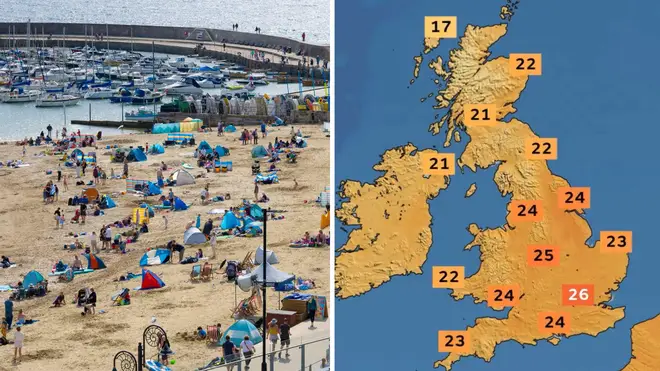
Brits are set to get one final taste of summer this weekend as a mini-heatwave hits, with temperatures set to soar into the high 20s.
A mini-heatwave is set to hit in coming days, with parts of the country expected to be warmer than Portugal.
Despite August being mostly cloudy and showery, September will bring more settled conditions.
Temperatures in London and south east England are forecast to peak at 27C while Lisbon is only expected to reach highs of 25C on Tuesday and Wednesday.
Across other parts of England and Wales, "pleasantly warm" temperatures of low to mid 20s are on the cards.
Read more: Boy, 7, who died in horror crash with BMW in Huddersfield named by police after man arrested
Want to know what the weather has in store this weekend? Here's Alex with the latest forecast 👇 pic.twitter.com/bRWCBz6XPL
— Met Office (@metoffice) August 31, 2023
The Met Office's Stephen Dixon said: "As we head through the weekend into early next week, temperatures are trending upwards, especially in the south.
"By the middle of next week, we could see temperatures reaching the mid-20s Celsius in the south east – or even a little higher, perhaps 26 – 27C – and sunny skies with high pressure influencing our weather and spreading across the UK."
The turn in temperatures comes as the UK enters meteorological autumn on Friday.
Meteorological summer runs from June 1 to August 31 before meteorological autumn begins on September 1 through to November 30.
The sunshine has arrived early for some on the south coast, with Brits heading to the beach in recent days. But other parts of the UK have experienced scattered showers this week.
We move into meteorological #Autumn tomorrow, but for most of us it will feel much more like summer by early next week!
— Met Office (@metoffice) August 31, 2023
Here's a look at how hurricane #Franklin and other factors are bringing about the change ⬇️ pic.twitter.com/j6DvDuu2dX
The return of the warm weather is partly down to the impact of Hurricane Franklin, which hit Bermuda with winds of up to 105mph on Wednesday.
The tropical storm caused a flow of warm air to move north from southern Europe, the Met Office said.
Meanwhile, Florida faced Hurricane Idalia, with high winds shredding signs, blowing off roofs, sending sheet metal flying and snapping tall trees.