Shelagh Fogarty 1pm - 4pm
26 September 2024, 16:23

More flooding is on the way for Britain amid continued thunderstorms, as a wet and windy week continues - and tornadoes could be in store too.
The Environment Agency has 27 flood warnings in place across England - which means flooding is expected - and 73 flood alerts, which means it is possible.
Bedfordshire, Northamptonshire and Oxfordshire in central England are currently the most vulnerable to flooding.
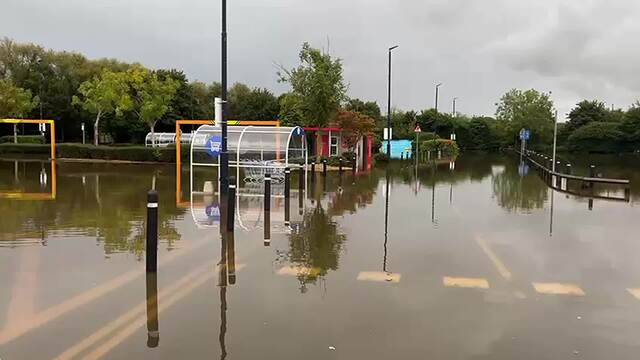
Footage and images have emerged of flooded streets and fields as heavy rain came down over the past few days.
A Tesco in the Oxfordshire town of Abingdon was forced to close because of heavy flooding.
Read more: Flood fears as new heavy rain warnings issued across much of England spanning three days

Much of the south-east is set to see lighting, winds reaching 50mph and even tornadoes, according to the Tornado and Storm Research Organisation (Toro).
This includes much of East Anglia, the south-east Midlands and central southern England.
Earlier on Thursday the Met Office issued an amber warning for areas of the Midlands and south of the country, set to come into force at 6pm on Thursday and last for 12 hours.
Areas affected by the amber warning, including Milton Keynes, Oxfordshire, Cambridgeshire, Leicestershire and the West Midlands, could see 30-40mm of rainfall within three hours.

Yellow rain warnings were already in place for large parts of England and Wales and western parts of Northern Ireland.
The Met Office said: "Slow moving showers and thunderstorms will develop through the afternoon, merging into a large band of heavy rain through the evening, before clearing slowly south overnight.
"Some places, especially across central and eastern parts of the warning area, are likely to receive 30-40mm in three hours or less, and perhaps 50-60mm or more in around six hours.
"This rain will fall onto already saturated ground and affect communities recovering from recent flooding.
"Travel disruption and further flooding is likely, with rivers continuing to rise after the rain clears."

Tesco floods amid heavy rain
Delays and cancellations to train and bus services and power cuts are also likely.
Parts of the country saw more than the monthly average rainfall on Monday, with flash flooding damaging homes and disrupting travel.
There were further downpours on Wednesday evening.
Around 385 properties were flooded in Hertfordshire, Bedfordshire, Northamptonshire, Kent and the Home Counties, according to the Environment Agency.
Kate Marks, flood duty manager at the agency, said: "Heavy rainfall across the country means that significant river and surface water flooding impacts are possible in parts of central England today and into Friday. Minor river flooding impacts are also possible in parts of north-east England today and Friday.

"Environment Agency teams continue to be out on the ground, supporting local authorities in responding to surface water flooding. We urge people to plan their journeys carefully, follow the advice of local emergency services on the roads and not to drive through flood water - it is often deeper than it looks and just 30cm of flowing water is enough to float your car.
"People should check their flood risk, sign up for free flood warnings and keep up to date with the latest situation as well as following @EnvAgency on X for the latest flood updates."
The rain is expected to clear during Friday leaving conditions much colder on Saturday.