Richard Spurr 1am - 4am
9 December 2023, 14:28 | Updated: 9 December 2023, 14:49

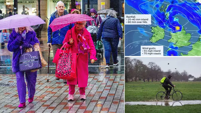
Britain faces two storms in a weekend washout, as newly-named Elin and Fergus roll in with 70mph gusts and communities are warned of floods.
A yellow weather warning for rain has been put in place for much of the North West, with the weather service saying it is "likely" homes will get flooded, and water on the roads could disrupt transport.
Some parts will get as much as 80mm of rainfall.
The alert is in place until 3am on Sunday as the government issued 33 flood warnings and 184 flood alerts.
Parts of South West England, Wales, the Midlands, East Anglia and areas in the north have been told to brace for gusts of up to 55mph that could bring delays to transport and even lead to short-term power loss.
Read more: Somerset and North Devon schools shut as heavy rain causes floods in South West England
#StormElin has been named by @MetEireann and is forecast to bring strong winds and heavy rain on Saturday
— Met Office (@metoffice) December 9, 2023
⚠️ Stay #weatheraware
Latest warning information 👉 https://t.co/QwDLMfRBfs pic.twitter.com/5pZDke4ZX3
Large waves were set to batter coastal towns at their sea front and lorries may need to go slower on bridges and exposed roads. That alert is due to clear by the end of Saturday.
The wind has been caused by low pressure in the western parts of the UK, and that system has been named Storm Elin.
Met Office Chief Meteorologist Andy Page said: "Wet and windy weather is the main theme of the forecast this weekend, though there will be some drier interludes in the south on Saturday afternoon.
"Winds and rain could be disruptive at times, which has resulted in the issuing of weather warnings for both wind and rain.
"Winds could peak around 70mph on exposed Irish Sea coasts, with gusts of around 45-55mph likely quite widely in England and Wales.
"A further 20-30mm of rain could fall over parts of Northern Ireland, northwest England and into southwest and central Scotland, with 40mm over some high ground."

Kate Marks, flood duty manager at the Environment Agency, said: "Minor river flooding impacts are expected across parts of England until Tuesday, following recent heavy rainfall and with further rain on Saturday.
"Minor surface water flooding is likely across parts of Somerset, Devon and Dorset on Saturday, with further minor impacts also possible elsewhere.
"We advise people to stay away from swollen rivers and urge people not to drive through flood water as just 30cm of flowing water is enough to move your car.
"People should check their flood risk, sign up for free flood warnings and keep up to date with the latest situation at https://www.gov.uk/check-if-youre-at-risk-of-flooding and follow @EnvAgency on X, formerly known as Twitter, for the latest flood updates."
And the bad weather is due to last into Sunday, with Storm Fergus bringing back gust winds, especially in western parts of the UK, although Ireland will bear the worst of it.
It comes just days after schools were forced to shut in Somerset and North Devon because of roads flooding after heavy rain.
Next week is forecast to be wet and windy for many due to an Atlantic influence.